
Last month my mom and I set out to explore several points of interest within our home state of West Virginia, places that neither she or I had visited before. Being from the coalfields in the southern part of the state, we chose to visit the Allegheny Highlands of eastern West Virginia. This region encompasses some of the highest peaks in the Allegheny Mountain chain.

The Allegheny Mountains are approximately 400 miles in length and are a part of the much longer Appalachian Mountain Range. Much of this area is protected under federal law as it is a part of the Monongahela National Forest. This area offers renowned outdoor recreation such as biking, caving, fishing, hiking, hunting, and skiing.
The majority of our first day was spent driving in and exploring Pocahontas County. Pocohantas is the third largest county in West Virginia according to size, but the eighth least populated (out of 55). Less than 9,000 people call its 940 square miles home. The county is nicknamed "the birthplace of rivers" because eight rivers originate within the county, yet no river flows into the county from surrounding counties.
CRANBERRY GLADES
Our first stop was at Cranberry Glades, which is located approximately 25 miles west of Richwood, WV and approximately 20 miles northeast of Hillsboro, WV near the junction of highways 39 and 150.
The Glades, as it is more commonly known, is a large 750-acre cluster of spongy peat blogs whose highly acidic soil supports an ecosystem more commonly found in subarctic climates like in the northern United States and Canada.

Cranberries, skunk cabbage, and the carnivorous purple pitcher plant, to name a few, can be found there.

This unique plant life is the result of the changing climate conditions that allowed glaciers to creep across the northern part of the continent 10,000 years ago. The migration of several species ended here, making Cranberry Glades the southernmost home to many them.


A half mile boardwalk allows visitors the opportunity to walk through two of the bogs for a closer view of the flora and sometimes fauna without disturbing the fragile ecosystem.


I have always heard that Cranberry Glades was such a unique area, but I really didn't understand how unique until I visited it. the entire time I was there, I kept thinking to myself, "This is in West Virginia?" for it felt like I was in a completely different geographical region.
What I liked best about The Glades is the relative silence. My mom and I shared the bog with two other visitors. Aside from their occasional conversation and one airplane that flew over, it was completely silent and still. It's one of the most peaceful places I've ever visited.
CASS SCENIC RAILROAD
Approximately 50 miles northeast of Cranberry Glades, on the banks of the Greenbrier River, is the sleepy little town of Cass. As of the 2010 census, Cass boasted a population of 52. That's right... 52!

Cass was established in 1902 as a company town for the employees of the West Virginia Pulp and Paper Company, who logged nearby Cheat Mountain. The logging mill, which once produced paper and hardwood flooring, closed in 1960. The railroad, which once brought the logs down the mountain to the town for processing, was purchased and converted into a tourist attraction in 1963. The majority of the town was later purchased and the area became the Cass Scenic Railroad State Park. Cass was placed on the National Register of Historic Places in 1980.


The Cass Scenic Railroad offers several excursions that transports its riders back in time to a long ago era when steam locomotives were an essential means of transportation. The most popular is the 4.5 hour trip to Bald Knob, which at 4842 feet, is the highest railroad point east of the Mississippi and the third highest peak in West Virginia. Pressed for time, my mom and I opted for the 2-hour trip to Whittaker Station.

After traveling approximately four miles up the track through the dense woods full of fresh, green foliage and passing through two switchbacks, we entered a meadow where an old logging camp has been recreated to illustrate both the living quarters and equipment used by the loggers decades before. This is Whittaker Station.


Although the historical aspect of Whittaker Station was interesting, in my opinion, the best part was the view. Once we cleared the trees, the vast, expansive horizon opened up before us and we could see miles to the east.

The stop at Whittaker Station was approximately 30 minutes, which is ample time to explore the recreated logging camp, use the restrooms, and visit the snack bar if one so desires. Although it was loud, I took the opportunity to check out the restored Shay locomotive, which was designed to climb the steepest grades and swing around hairpin curves while hauling heavy loads.


Upon returning to town, we ate a late lunch in The Last Run Restaurant. The Last Run is located right next to the Company Store and offers a variety of lunch and dinner items with local flavor. I had the pulled pork sandwich and it was rather tasty! The restaurant was featured in the "101 Unique Place to Dine (in West Virginia)" in 2009 and 2015.


Upon returning to town, we ate a late lunch in The Last Run Restaurant. The Last Run is located right next to the Company Store and offers a variety of lunch and dinner items with local flavor. I had the pulled pork sandwich and it was rather tasty! The restaurant was featured in the "101 Unique Place to Dine (in West Virginia)" in 2009 and 2015.

GREEN BANK OBSERVATORY
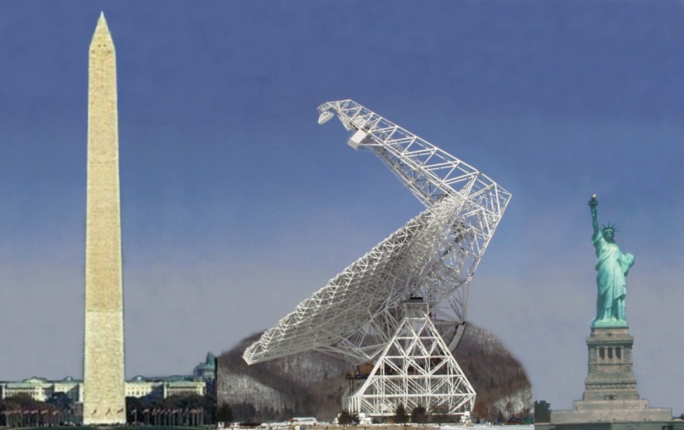
Seven miles from Cass is the little community of Green Bank, population 152. The Green Bank Observatory, which once was a part of the National Radio Astronomy Observatory, is located here and is the home to eight telescopes, including the gargantuan Robert C. Byrd Green Bank Telescope (GBT), the world's largest fully steerable radio telescope.
Trust me, I don't use the word gargantuan lightly! This sucker is over 485 feet tall and has a surface area of 2.3 acres, which could hold two whole football fields. Here is what it would look like in comparison to some other commonly known landmarks:
The large surface area is what allows the GBT to collect the faintest radio waves from space. The structure took 10 years to build to the tune of $100 million. (For a more technical explanation of the what the GBT is capable of click here for a short, but informative National Geographic video.)

In the Green Bank Science Center, visitors can walk through the Catch the Wave Exhibit Hall which is full of hands on scientific exhibits about space and how these radio telescopes work. Entry into the exhibit hall is free. For a mere $6, visitors can watch an informative video and take a guided tour out amongst the telescopes. We were fortunate, for we were able to catch the last guided tour of the day.
Be advised - due to the sensitivity of the telescopes, cameras and phones must be turned off before proceeding beyond a unarmed Checkpoint Charlie type gated area. As a result, visitors are not able to get close up photos. Apparently, the telescopes are so sensitive that these items can, in our guides own words, make an astronomer's day go really bad. This was as close of a picture that I could get:

Elkins is the county seat of Randolph County, which is the largest county in West Virginia with 1040 square miles. Elkins is also the home of Davis & Elkins College, a small, private liberal arts college.
Although Elkins is by no means a large, bustling metropolis, with a population of approximately 7,000, it is large enough to offer a variety of amenities such as basic shopping, dining, lodging, and cellular service. Our home for the next two nights was the Hampton Inn, which, despite the brightly lit signs of civilization below, still offered a very pretty view:


Please join me next week for Part 2!
As always, thanks for stopping by!


 |
| Source |
Trust me, I don't use the word gargantuan lightly! This sucker is over 485 feet tall and has a surface area of 2.3 acres, which could hold two whole football fields. Here is what it would look like in comparison to some other commonly known landmarks:
 |
| Source |
The large surface area is what allows the GBT to collect the faintest radio waves from space. The structure took 10 years to build to the tune of $100 million. (For a more technical explanation of the what the GBT is capable of click here for a short, but informative National Geographic video.)

In the Green Bank Science Center, visitors can walk through the Catch the Wave Exhibit Hall which is full of hands on scientific exhibits about space and how these radio telescopes work. Entry into the exhibit hall is free. For a mere $6, visitors can watch an informative video and take a guided tour out amongst the telescopes. We were fortunate, for we were able to catch the last guided tour of the day.
Be advised - due to the sensitivity of the telescopes, cameras and phones must be turned off before proceeding beyond a unarmed Checkpoint Charlie type gated area. As a result, visitors are not able to get close up photos. Apparently, the telescopes are so sensitive that these items can, in our guides own words, make an astronomer's day go really bad. This was as close of a picture that I could get:

ELKINS
Upon leaving Green Bank, we continued north through the Monongahela National Forest for approximately 50 miles to the town of Elkins, which served as our home for the next two nights.Elkins is the county seat of Randolph County, which is the largest county in West Virginia with 1040 square miles. Elkins is also the home of Davis & Elkins College, a small, private liberal arts college.
Although Elkins is by no means a large, bustling metropolis, with a population of approximately 7,000, it is large enough to offer a variety of amenities such as basic shopping, dining, lodging, and cellular service. Our home for the next two nights was the Hampton Inn, which, despite the brightly lit signs of civilization below, still offered a very pretty view:

Know Before You Go
- After leaving the tiny community of Hillsboro on US 219, we did not have cell service until we were approximately 15-20 miles outside of Elkins later that night. Do not plan to use your phone's map service while you are in this area. I'm not sure if in-car navigational systems work or not. Be prepared - bring printed directions and a good map.
- Although there is no cellular service in the town of Cass, the town does offer extensive free Wi-Fi that covers a large portion of the town.
- Also, due to the higher elevation, the weather can change drastically. I would advise you to bring warmer layers that you can easily put on if you need to, especially if you plan to ride the scenic train.
- Due to the nature of the locomotive, hot cinders and soot are to be expected.

- Traveling in this part of the state is predominantly on twisting, turning two-lane roads which are not for the faint of heart. Allow for additional travel time and if you are prone to car sickness, you may want to take the proper precautions.
Please join me next week for Part 2!
As always, thanks for stopping by!
Linking up with:

&


Everything looked beautiful and sounds like you and your mom had some good fun quality time together
ReplyDeleteLooks like a lovely trip, but I would definitely be staying away from that flesh eating flower! Never seen that before! Thanks for linking up with #TheWeeklyPostcard!
ReplyDelete(www.caliglobetrotter.com)
What a beautiful area and that science center seems really interesting. I would love to learn more about how those telescopes work. Thanks for sharing on #TheWeeklyPostcard.
ReplyDeleteThe glades seem to be the perfect destination for a day trip in the summertime! I certainly would love to spend a day there just strolling around and enjoying the views and hopefully some sunshine :)
ReplyDelete